Use the “Coordinates” section to configure the units and projection system used by the project.
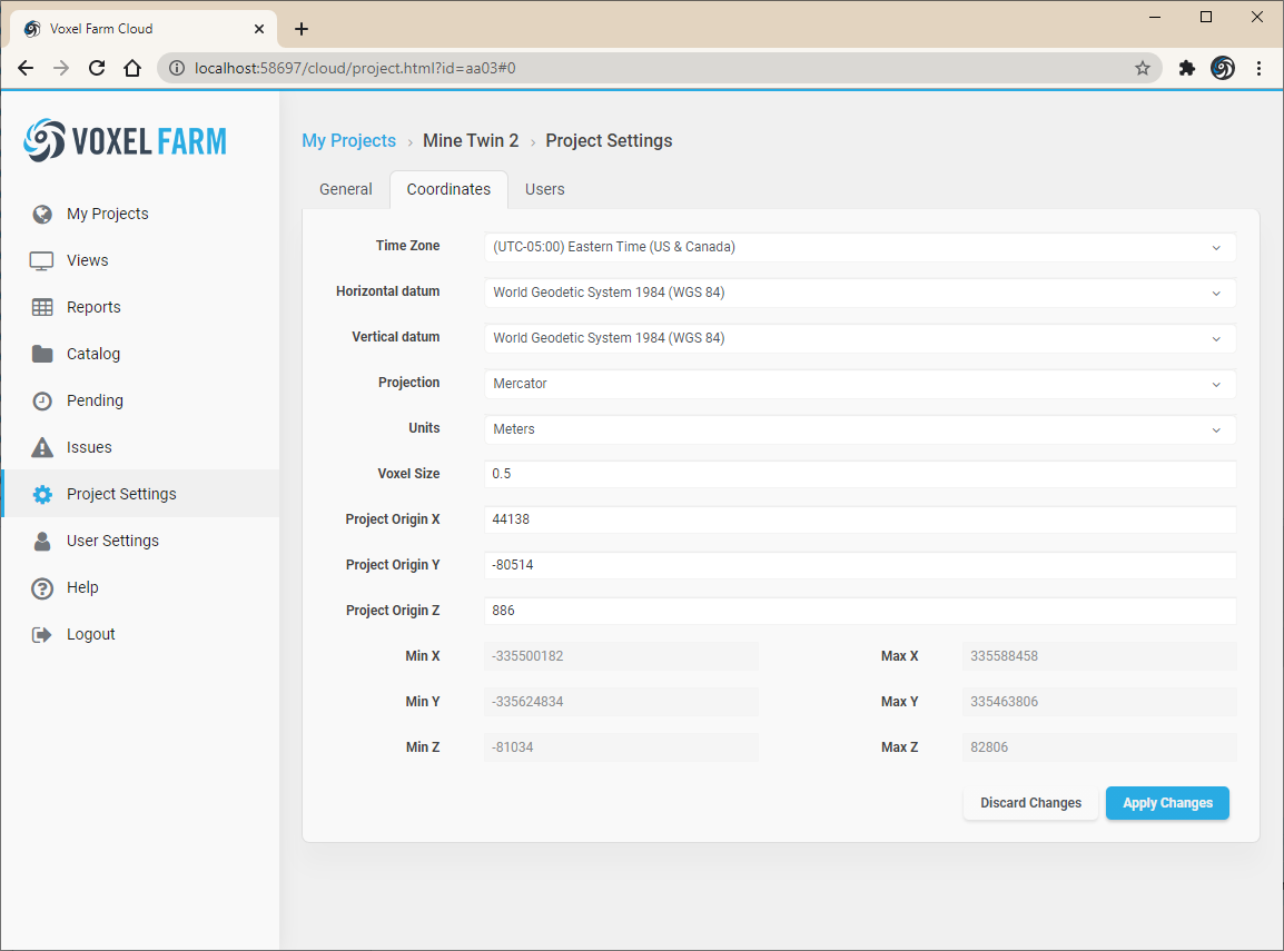
The following table lists the properties found in the Coordinates section and describes their use:
|
Time Zone
|
The time zone for the project’s location.
|
|
Horizontal datum
|
Horizontal datum used by the project. These are the supported horizontal datums:
- World Geodetic System 1972 (WGS 72)
- World Geodetic System 1984 (WGS 84)
- Geodetic Reference System 1980 (GRS 80)
- North American Datum 1927 (NAD27)
- North American Datum (NAD83)
- North American Datum (NAD83 2011)
- North American Datum (NAD83 HARN)
- North American Datum (NAD83 CSRS)
- Geocentric Datum of Australia 1994 (GDA94)
- European Terrestrial Reference System 1989 (ETRS89)
- Australian Geodetic Datum 1966 (AGD66)
|
|
Vertical datum
|
Vertical datum used by the project. These are the supported vertical datums:
- World Geodetic System 1984 (WGS 84)
- National Geodetic Vertical Datum 1929 (NGVD 29)
- North American Vertical Datum 29 (NAVD 29)
- Canadian Geodetic Vertical Datum 2013 (CGVD 2013)
- Canadian Geodetic Vertical Datum 1928 (CGVD 28)
- Denmark Vertical Reference (DVR 90)
- Norway Normal Null 2000 (NN2000)
- Norway Normal Null 1954 (NN54)
- Deutsches Haupthoehennetz 1992 (DHHN92)
- North American Vertical Datum 1988 (NAVD 88)
- North American Vertical Datum 1988 (NAVD 88 GEOID12B)
- North American Vertical Datum 1988 (NAVD 88 GEOID12A)
- North American Vertical Datum 1988 (NAVD 88 GEOID12)
- North American Vertical Datum 1988 (NAVD 88 GEOID09)
- North American Vertical Datum 1988 (NAVD 88 GEOID06)
- North American Vertical Datum 1988 (NAVD 88 GEOID03)
- North American Vertical Datum 1988 (NAVD 88 GEOID99)
- North American Vertical Datum 1988 (NAVD 88 GEOID96)
|
|
Projection
|
Projection used by the project. These are the supported projections:
- Latitude Longitude
- Longitude Latitude
- Earth Centered Earth Fixed
- Mercator
- Universal Transverse Mercator (UTM)
- Transverse Mercator
- Lambert conformal conic
- AEAC
- AMG
- MGA
|
|
Units
|
Determines whether units represent meters of feet.
|
|
Voxel Size
|
Voxels are cubes. This parameter determines the length all sides in a voxel’s cube.
|
|
Project Origin X, Y, Z
|
The origin coordinates of the project, in units. This point becomes a reference point for the project.
|
|
Min X, Y, Z (read-only)
|
Minimum possible coordinates in the project.
|
|
Max X, Y, Z (read-only)
|
Maximum possible coordinates in the project.
|